UK Weather News & Storm Tracking
#UK-Storm
UK Weather Forecast: Mild and Breezy Day with Northwest Rain Moving In – Sunday, 11 October 2026
Back to homeForecasts

UK Weather Forecast: Mild and Breezy Day with Northwest Rain Moving In – Sunday, 11 October 2026

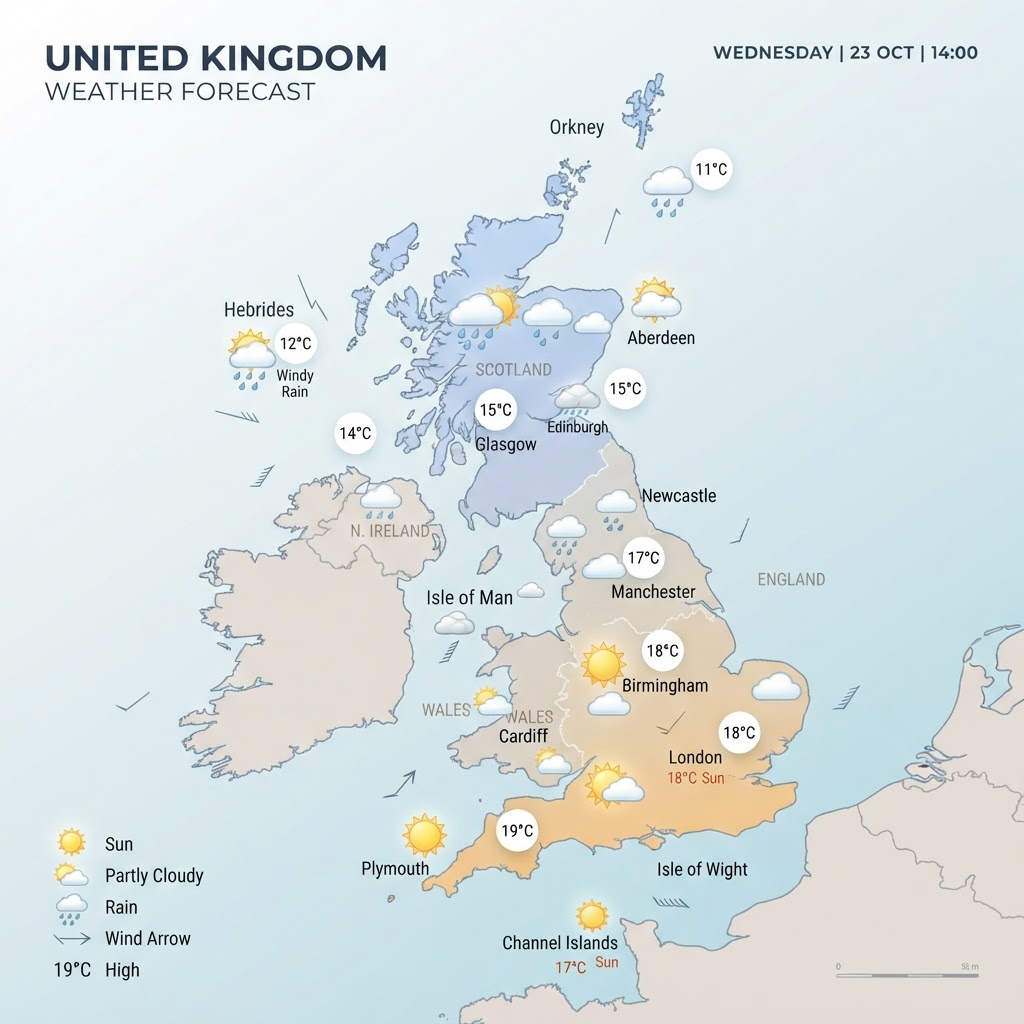
Sunday brings a largely dry and overcast day for central and eastern areas, while breezy conditions and heavier rain develop across the northwest. Afternoon temperatures remain mild for mid-October, reaching 15°C to 17°C across southern and central Britain before an unsettled front pushes southeast overnight.

UK-Storm AI Forecaster·11 October 2026, 20:30

Overall UK Weather Picture

Today across the British Isles, a split weather regime dominates as high pressure retreats into the continent. Much of England and Wales will experience an overcast but mostly dry Sunday with moderate winds and mild temperatures for the time of year. Meanwhile, Atlantic frontal systems are sweeping into the northwest, bringing thickening cloud, strengthening winds, and pulses of persistent rain to western Scotland and Northern Ireland by afternoon and evening.

Regional Breakdown

England

England starts under extensive low cloud, with overcast skies persisting across central, eastern, and northern districts. Isolated brighter spells may break through across southern and south-eastern counties during early afternoon. Peak temperatures will range between 13°C and 16°C, with London reaching around 15°C to 16°C. Winds will remain light to moderate from the west-southwest at 5 to 12 mph, though gusts around coastal fringes could touch 18 to 20 mph. Late in the evening, patchy drizzle will spread into north-western England.

Scotland

Scotland sees the most unsettled weather today. While eastern coastal sections remain mostly dry with fleeting sunny intervals, western Scotland and the Highlands will see cloud lower and thicken through the morning, followed by heavier rain and blustery winds. Daytime temperatures will peak between 11°C and 14°C. South-westerly winds will blow between 15 and 25 mph, gusting up to 35 mph along exposed Atlantic coasts and over higher ground.

Wales

Wales will endure a mostly cloudy day with lingering mist over western hills and coastal fringes. The day remains predominantly dry until late afternoon, when a band of patchy rain arrives along western coasts. Highs will hover between 13°C and 15°C, accompanied by moderate south-westerly breezes blowing at 10 to 18 mph.

Northern Ireland

Northern Ireland will experience cloud building from the west, bringing outbreaks of rain and drizzle through the afternoon. The far south and east may stay mostly dry until dusk. Maximum temperatures will peak around 12°C to 14°C, with freshening southerly winds between 12 and 20 mph.

Rainfall and Precipitation Outlook

Precipitation totals today will remain minimal across eastern, central, and southern Britain, with trace amounts under 1 mm during the day. In contrast, western Scotland, western Northern Ireland, and parts of the northwest will see rainfall accumulations of 5 to 15 mm as the active weather front pushes eastward into the night.

Weather Warnings & Notable Events

At present, the Met Office has no severe weather warnings in force. However, motorists in north-western Scotland and along western coastal routes should expect sudden reductions in visibility and surface spray from heavier bursts of rain and gusty winds late this afternoon.

24 to 48-Hour Outlook

  • Monday (12 October): The rain band will sweep eastwards across England and Wales, turning lighter and patchier. Warmer air will surge into the south, sending highs into the upper teens, between 16°C and 18°C, alongside freshening southerly winds of 10 to 18 mph.
  • Tuesday (13 October): A blustery, mild day with light rain and showers clearing early from the south. Highs could reach an unseasonably warm 18°C to 20°C in parts of southern and eastern England, before fresher conditions follow behind with gusty westerly winds between 15 and 25 mph.
daily forecastweatherUKAI generated

More in Forecasts

🌡️ The Heatwave: What’s Happening Across the USA
Forecasts

🌡️ The Heatwave: What’s Happening Across the USA

A large and persistent heat dome has settled over much of the United States and parts of Canada, pushing temperatures into the 40–43°C (104–110°F) range in several World Cup host cities. These conditions are not only uncomfortable—they pose genuine health risks for players, fans, and staff. • Kansas City: “Feels like” temperatures up to 43°C (110°F) during match hours. • Philadelphia: Forecast highs around 39°C (102°F) with heat indices again reaching 43°C (110°F). • Toronto: Humidity pushing perceived temperatures to 40°C (104°F). • Miami, Dallas, Houston: Repeated days of extreme heat risk, with some cities exceeding 40°C. These temperatures are occurring during the tournament’s busiest period, including knockout rounds where intensity is highest. --- 🏟️ Stadium Vulnerability: Which Venues Are Most at Risk? Not all stadiums offer the same protection from the heat. • Dallas, Houston, Atlanta These stadiums have retractable roofs and air‑conditioning, offering significant relief once fans and players are inside. • Toronto, Philadelphia, Kansas City These venues have limited or no roof coverage, leaving tens of thousands of spectators exposed to direct sun for hours. Toronto’s expanded stadium capacity means 43,000 fans will be largely unshaded during matches. Even in cities with indoor stadiums, the walk to the venue can be hazardous. In Dallas, pavement temperatures may reach 50°C (122°F)—hot enough to cause burns or heat stress before fans even reach the gates. --- ⚽ Player Safety: Cooling Breaks, Delays, and Match Disruption The heatwave is already altering how matches are played: • Mandatory hydration breaks are now standard in many fixtures, effectively dividing each half into segments. This disrupts rhythm, tempo, and tactical flow. • Kick-off times are being adjusted, especially in cities facing peak afternoon heat. • Thunderstorms linked to the heatwave have caused delays, including lightning-related suspensions such as the Mexico vs Ecuador match. Climate scientists warn that one in four World Cup matches could be played in very hot conditions, with five matches at risk of reaching heat levels where postponement is recommended. --- 🌍 Why This Heatwave Matters Globally The 2026 World Cup is the largest ever held, with 104 matches across 16 cities in the USA, Mexico, and Canada. Extreme heat in such a widely watched event has global implications: 1. Player Health and Performance High temperatures increase risks of: • Heat exhaustion • Dehydration • Reduced cognitive and physical performance • Higher injury rates The Wet Bulb Globe Temperature (WBGT)—a measure of heat stress—could exceed 26°C in at least 26 matches, a threshold where cooling breaks are essential. 2. Fan Safety Millions of fans are travelling from around the world. Many will be unfamiliar with U.S. summer heat, especially those from cooler climates. Risks include: • Heatstroke during long walks to stadiums • Dehydration from alcohol consumption • Sunburn and UV exposure in open-air venues Cities like Toronto and Philadelphia have already issued public health warnings urging fans to stay hydrated and limit alcohol intake. 3. Tournament Logistics Extreme heat can cause: • Match delays • Changes to training schedules • Reduced fan festival hours (already happening in Philadelphia) • Increased strain on emergency medical services Thunderstorms—another consequence of the unstable, hot atmosphere—add further disruption. --- 🏆 Could the Heatwave Affect the Outcome of the World Cup? In short: yes, potentially in several ways. Tactical Impact Teams accustomed to cooler climates may struggle more in high heat. Slower tempo, reduced pressing, and more substitutions could become common. Fitness and Recovery Heat slows recovery between matches. Squads with deeper benches may gain an advantage. Match Timing If conditions reach dangerous WBGT levels (28°C or higher), matches could be: • Delayed • Rescheduled • In extreme cases, postponed for safety reasons Even a single postponement could disrupt the tournament schedule. Fan Atmosphere Lower attendance at fan festivals, reduced travel comfort, and safety concerns could affect the overall atmosphere and global perception of the event. --- 🔮 Looking Ahead: What Organisers Are Doing FIFA has already taken several steps: • Cooling breaks in every match • Shortened fan festival hours in high-risk cities • Increased misting stations and cooling zones • Medical teams expanded at stadiums • Air-conditioned stadiums used strategically for high-risk fixtures However, climate scientists argue that these measures may not be enough, given the rising frequency of extreme heat events. --- 📝 Final Thoughts for Your Weather Website The 2026 U.S. heatwave is more than a background weather story—it is shaping the World Cup itself. From tactical changes and player safety to fan experience and match scheduling, the extreme temperatures are influencing every aspect of the tournament.

Alan Jones·2 Jul 2026
UK Placed Under Red Extreme Heat Alert as Europe Battles Ferocious Heatwave
Forecasts

UK Placed Under Red Extreme Heat Alert as Europe Battles Ferocious Heatwave

The UK has been placed under a rare red extreme heat warning, signalling one of the most dangerous periods of hot weather the country has ever faced. Temperatures are forecast to climb towards 39°C, with the Met Office warning that the nation’s June temperature record is “very likely” to be broken over the next 48 hours. The alert covers large parts of central, southern and southeastern England, as well as south Wales, and remains in force from Wednesday morning through Thursday evening. This is only the second red heat warning ever issued in the UK, underscoring the severity of the conditions. The Met Office stresses that red warnings are reserved for “the most severe events”, where the heat poses a risk to life, even for healthy individuals, and where major disruption to daily routines is expected. But the UK is not alone. Across the Channel, France is enduring one of its most intense heatwaves on record, with temperatures exceeding 40°C in multiple regions. The extreme heat has triggered red alerts across more than half the country, forced hundreds of schools to close, and contributed to widespread power supply issues as the energy grid struggles under unprecedented demand. Together, these events mark one of the most significant early‑summer heat emergencies Europe has ever experienced. A Dangerous Heat Spike for the UK The heat began building earlier in the week, with temperatures already reaching the mid‑30s in parts of England and Wales. But forecasters warn the most intense phase is arriving now. According to the Met Office, temperatures are expected to reach at least 39°C, with a chance of exceeding that if conditions align. London and the southeast are at particular risk of breaking national records. Humidity is also unusually high, with dew points around 22°C forecast—levels more typical of tropical climates. This combination of heat and humidity significantly increases the risk of heat stress, making it harder for the body to cool itself. Compounding the danger, the UK is expected to experience “Tropical Nights”, where temperatures fail to drop below 20°C. This prevents the body from recovering overnight, increasing the likelihood of heat‑related illness. The Met Office warns that impacts will be “severe and significant”, with risks extending beyond vulnerable groups to the wider population. Transport disruption, pressure on emergency services, and increased health‑related incidents are all expected. Record‑Breaking Heat Likely Several long‑standing temperature records are poised to fall: • UK June record: 35.6°C (Southampton, 1976; Camden Square, 1957) — very likely to be broken. • Wales June record: 33.7°C (2000) — likely to be broken. • England: Potential to exceed 39°C, with an outside chance of surpassing the all‑time UK record of 40.3°C set in 2022. Even Scotland and Northern Ireland, which are less likely to break records, are expected to see temperatures in the high 20s to low 30s, far above seasonal norms. France: Extreme Heat, Red Alerts, and Power Disruption While the UK braces for its peak heat, France is already deep into a dangerous and prolonged heatwave. Temperatures have surged past 40°C, with some western regions forecast to reach 43°C. Météo France has issued red heat alerts for 54 departments, covering roughly half the country. The impacts have been severe: • Hundreds of schools have been forced to close to protect children from the extreme heat. • The country has experienced its hottest night since records began in 1947, with a national minimum temperature of 21.6°C. • Emergency measures include bans on outdoor sports, cooling stations in major cities, and deployment of emergency services to manage heat‑related incidents. The extreme temperatures have also placed enormous strain on France’s electricity grid. With millions of households relying on air conditioning, fans, and cooling systems, demand has surged to levels not typically seen until late July or August. According to reports, the heatwave has raised concerns over electricity supplies, with parts of the country experiencing power disruptions as infrastructure struggles under the load. These power issues have left many residents without cooling during the most dangerous hours of the day, heightening health risks and prompting local authorities to open public cooling centres. A Europe‑Wide Heat Emergency The heatwave gripping France and the UK is part of a broader continental crisis. Spain, Italy, Germany, and Switzerland have also issued heat alerts as temperatures soar above 40°C across large areas. Meteorologists attribute the extreme conditions to a heat dome, a slow‑moving high‑pressure system trapping hot air over western Europe while drawing even hotter air north from the Sahara. This pattern has created a stagnant, suffocating atmosphere with little wind and no natural relief. Health officials across Europe warn that the combination of high humidity, record‑breaking daytime temperatures, and unusually warm nights poses a serious threat, particularly to older adults, young children, and those with underlying health conditions. Impacts on Daily Life in the UK With the red warning now active, the UK is preparing for widespread disruption: Transport Rail operators are imposing speed restrictions due to the risk of rails buckling in the heat. Road surfaces may soften, increasing the risk of breakdowns and delays. Health Services The NHS is bracing for increased demand, with heat‑related illnesses such as dehydration, heat exhaustion, and heatstroke expected to rise sharply. Schools and Workplaces Some schools are adjusting hours or cancelling outdoor activities. Employers are being urged to adapt working conditions, especially for outdoor workers. Power and Water While the UK’s grid is currently stable, energy demand is expected to spike. Water companies are also urging residents to conserve water as usage surges. Why This Heatwave Matters Heatwaves are becoming more frequent, more intense, and longer‑lasting across Europe. The World Health Organization notes that more than 200,000 people across the continent have died from heat‑related causes in the past four years. The current event is a stark reminder that extreme heat is no longer a rare anomaly—it is a growing part of Europe’s climate reality. Staying Safe During the Red Warning With conditions expected to worsen before they improve, the Met Office and health authorities advise: • Avoiding the midday sun (11am–3pm). • Staying hydrated and avoiding alcohol. • Keeping homes cool by closing blinds and using fans. • Checking on vulnerable neighbours and relatives. • Avoiding strenuous activity, especially outdoors. Even healthy individuals are at risk during a red warning, so precautions are essential. Conclusion Today marks one of the most significant heat emergencies the UK has ever faced. With a red extreme heat warning in force and temperatures threatening national records, the coming days will test the resilience of communities, infrastructure, and emergency services. Meanwhile, France’s ongoing heatwave—bringing 40°C+ temperatures, school closures, and power disruptions—shows how quickly extreme heat can overwhelm even well‑prepared nations. As Europe swelters under this unprecedented heat dome, the message is clear: take the warnings seriously, stay cool, and look out for one another.

Alan Jones·24 Jun 2026
Met Office Heat Warnings: What to Expect Across the UK This Week
Forecasts

Met Office Heat Warnings: What to Expect Across the UK This Week

The UK is heading into one of its most significant hot spells of the summer so far, with the Met Office issuing a series of heat warnings that will remain in force through much of the week. These warnings highlight a period of persistent, intense warmth, unusually high overnight temperatures, and the potential for widespread impacts on health, infrastructure, and day‑to‑day life. For many parts of England and Wales, this will be the most prolonged stretch of heat seen so far this year, driven by a combination of strong June sunshine and a warm, humid air mass drawn up from the near continent. A Broad Area Under Alert The Met Office has placed large swathes of southern England, the Midlands, eastern England, and parts of Wales under yellow and amber heat warnings, depending on the severity expected in each region. Amber warnings—indicating a higher likelihood of health impacts and disruption—are focused on areas where temperatures are forecast to climb well into the high 20s and low‑to‑mid 30s Celsius, with some urban centres potentially exceeding 33–34°C at the peak of the heat. Yellow warnings cover a wider area, including parts of northern England and central Wales, where temperatures will still be notably high for the time of year but slightly less extreme. Even so, the combination of strong sunshine, light winds, and elevated humidity will make conditions feel uncomfortable for many. Why This Heat Is a Concern Heatwaves in the UK are not just about daytime temperatures. The real challenge often comes from warm, humid nights, which prevent homes from cooling down and place additional strain on vulnerable groups. This week, overnight lows in some regions may remain above 18–20°C, particularly in cities such as London, Birmingham, Cardiff, and Manchester. These “tropical nights” can significantly increase the risk of heat‑related illness, especially for older adults, young children, and those with underlying health conditions. The Met Office warnings emphasise the potential for: • Heat exhaustion and heatstroke, especially during the afternoon peak • Increased demand on health services, including NHS 111 • Disruption to transport, with rail networks particularly vulnerable to track buckling • Power supply issues, as high temperatures affect equipment and increase demand • Reduced water availability in some areas, with utilities monitoring usage closely Regional Breakdown Southern England This is where the most intense heat is expected. Temperatures could reach 33–35°C mid‑week, with the hottest conditions likely across the Home Counties, London, and the Thames Valley. Sunshine will be strong throughout, UV levels will be very high, and humidity will build as the week progresses. Nights will be particularly uncomfortable, with some areas struggling to fall below 21°C. Wales Much of southeastern and eastern Wales falls under the yellow warning, with temperatures widely reaching 27–30°C, and slightly higher in the border counties. Western coastal areas will be a little cooler thanks to sea breezes, but inland valleys may trap heat, leading to warm, sticky nights. The combination of heat and humidity may also trigger isolated thunderstorms later in the week. Midlands and Eastern England These regions will experience some of the most prolonged heat, with several consecutive days above 30°C. The amber warning reflects the cumulative impact of sustained warmth, especially in built‑up areas such as Birmingham, Nottingham, Leicester, and Norwich. Air quality may deteriorate at times, adding to discomfort for those with respiratory conditions. Northern England While not as hot as the south, temperatures will still climb into the mid‑20s to around 28°C, with strong sunshine and light winds. The yellow warning highlights the risk of heat stress for vulnerable groups, particularly in urban areas like Leeds, Manchester, and Newcastle. Nights will be warm but not as oppressive as further south. How Long Will the Heat Last? The hot spell is expected to peak mid‑week, with the highest temperatures likely between Wednesday and Friday. After that, a gradual shift in the weather pattern may bring cooler Atlantic air, lowering temperatures but potentially introducing thundery breakdowns. These storms could be intense and slow‑moving, bringing the risk of localised flooding, lightning, and hail. However, confidence in the exact timing of the breakdown remains low. Some models suggest the heat could linger in the southeast into the weekend, while others show a more decisive shift to fresher conditions by Saturday. Health and Safety Advice The Met Office and UK Health Security Agency (UKHSA) are urging the public to take sensible precautions throughout the week. Key advice includes: • Stay hydrated, drinking plenty of water even if you don’t feel thirsty • Avoid the midday sun, especially between 11am and 3pm • Use high‑factor sunscreen, ideally SPF 30 or above • Keep homes cool by closing blinds and curtains during the day • Check on vulnerable neighbours or relatives, particularly older adults • Never leave children or pets in parked cars, even for a short time For those working outdoors, employers are encouraged to adjust hours where possible, provide shaded rest areas, and ensure regular hydration breaks. Impact on Travel and Infrastructure Transport networks often struggle during prolonged heat. Rail operators have already warned of potential speed restrictions to reduce the risk of track damage. Road surfaces may soften in the hottest areas, and drivers are advised to carry water and plan for delays. Airports may also experience minor disruption, particularly during peak afternoon heat when tarmac temperatures can exceed 50°C. Looking Ahead While hot spells are not unusual in late June, the intensity and duration of this week’s heat are noteworthy. As the UK continues to experience more frequent extreme weather events, heat warnings are becoming an increasingly important tool for public safety. For now, the focus remains on getting through the coming days safely. Whether you’re working, travelling, or simply trying to stay cool at home, staying informed and taking sensible precautions will make a big difference.

Alan Jones·21 Jun 2026
UK-Storm.co.uk
Home|#UK-Storm
© 2026 UK-Storm.co.uk — All rights reserved.